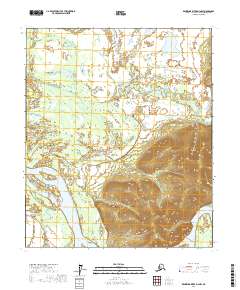
2017 Map of Kantishna River D-3 NW
USGS Topo · Published 2017About this map
The Tanana River dominates this interior landscape, carving a wide path through the southern half of the region. This 2017 survey illustrates a complex network of waterways, where the river meets the Cosna Slough beneath the rising elevation of Cosna Bluff. The shifting nature of these glacial waters is evident in the intricate winding of Williams Slough and Little Williams Slough, which weave through the low-lying terrain north of the main channel.
Find a feature on this map
11 named features on this map. Tap any name to fly to it.
Don’t see what you’re looking for? This feature index may not catch every label — zoom into the map to look around manually.
Map Details
Editions of this 2017 Kantishna River D-3 NW Map
This is the sole edition of this map. No revisions or reprints were ever made.
Other maps of this area

1948 · Kantishna River
USGS Topo · 1:250,000

1951 · Kantishna River
USGS Topo · 1:250,000

1951 · Tanana
USGS Topo · 1:250,000

1952 · Tanana A-3
USGS Topo · 1:63,360

1952 · Tanana A-4
USGS Topo · 1:63,360

1952 · Kantishna River
USGS Topo · 1:250,000

1952 · Kantishna River D-3
USGS Topo · 1:63,360

1953 · Tanana A-3
USGS Topo · 1:63,360
1953 · Kantishna River D-4
USGS Topo · 1:63,360
1954 · Kantishna River D-3
USGS Topo · 1:63,360