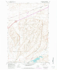
1964 Map of Karakul Hills
USGS Topo · Published 1982About this map
The Karakul Hills define the central topography of this Adams County landscape, where the agricultural economy of the mid-20th century relied heavily on the corridor of the Burlington Northern railroad. The Keystone Grain Elevator serves as a primary industrial landmark in the north, while small rural clusters like Stockman and Lugenbeal indicate the dispersed settlement patterns typical of the era. To the south, the terrain transitions into the wetlands and drainages surrounding Cow Lake and Hallin Lake, fed by the meandering path of Cow Creek.
Find a feature on this map
22 named features on this map. Tap any name to fly to it.
Don’t see what you’re looking for? This feature index may not catch every label — zoom into the map to look around manually.
Map Details
Editions of this 1964 Karakul Hills Map
2 editions found
Other maps of this area

1953 · Ritzville
USGS Topo · 1:250,000

1959 · Ritzville
USGS Topo · 1:250,000

1964 · Karakul Hills
USGS Topo · 1:24,000

1964 · Macall
USGS Topo · 1:24,000

1964 · Palm Lake
USGS Topo · 1:24,000

1964 · Marengo
USGS Topo · 1:24,000

1965 · Ritzville
USGS Topo · 1:250,000

1967 · Ritzville SE
USGS Topo · 1:24,000

1967 · Ritzville NE
USGS Topo · 1:24,000

1969 · Sprague Lake
USGS Topo · 1:24,000