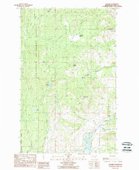
1988 Map of Karamin
USGS Topo · Published 1988About this map
Franson Peak and its Lookout Tower command the northeastern horizon of this section of the Colville National Forest in the late 1980s. The landscape is defined by its drainage basins, with Trout Creek and Bacon Creek carving through the southwestern terrain while Empire Creek flows toward the east. Small mountain settlements and clearings like Emanuel, Malo, and Karamin sit along the lower elevations, connected by a network of unimproved roads and 4wd tracks that suggest a history of timber management or fire access. High-altitude meadows, such as Lundimo Meadows, break up the timbered slopes between Granite Mountain and Mt Elizabeth. Notable water features including Empire Lake and Ward Lake provide key landmarks for those tracing the historical hydrology and land use patterns of this Ferry County region.
Find a feature on this map
31 named features on this map. Tap any name to fly to it.
Don’t see what you’re looking for? This feature index may not catch every label — zoom into the map to look around manually.
Map Details
Editions of this 1988 Karamin Map
This is the sole edition of this map. No revisions or reprints were ever made.
Other maps of this area

1904 · Republic
USGS Topo · 1:125,000

1948 · Curlew
USGS Topo · 1:62,500

1948 · Republic
USGS Topo · 1:62,500

1951 · Wauconda
USGS Topo · 1:62,500

1951 · Curlew
USGS Topo · 1:62,500

1951 · Bodie Mountain
USGS Topo · 1:62,500

1951 · Republic
USGS Topo · 1:62,500

1954 · Okanogan
USGS Topo · 1:250,000

1958 · Okanogan
USGS Topo · 1:250,000

1958 · Aeneas
USGS Topo · 1:62,500