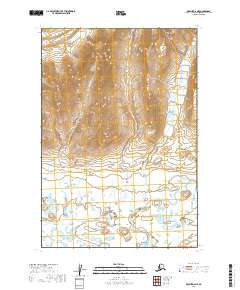
2019 Map of Karluk D-6 NE
USGS Topo · Published 2019About this map
The Becharof National Wildlife Refuge encompasses the central landscape of this quadrangle, preserving a wilderness where the Aleutian Range meets the coastal lowlands. The terrain is defined by the sharp elevations of the Kejulik Mountains to the north, which give way to a sprawling complex of tundra and wetlands as the land slopes toward the south. The hydrological network is dominated by the meandering Kejulik River, which snakes across the southern portion of the map, fed by smaller tributaries like Marie Cr. This 2019 survey illustrates the characteristic topography of the Alaska Peninsula, where high ridges transition into wide, water-logged valleys shaped by glacial and volcanic activity. The lack of any roads or permanent settlements underscores the protected and remote nature of this segment of the Lake and Peninsula Borough.
Find a feature on this map
11 named features on this map. Tap any name to fly to it.
Don’t see what you’re looking for? This feature index may not catch every label — zoom into the map to look around manually.
Map Details
Editions of this 2019 Karluk D-6 NE Map
This is the sole edition of this map. No revisions or reprints were ever made.
Other maps of this area

1948 · Mt Katmai
USGS Topo · 1:250,000

1951 · Mt Katmai
USGS Topo · 1:250,000

1951 · Karluk
USGS Topo · 1:250,000

1951 · Mount Katmai A-6
USGS Topo · 1:63,360

1951 · Karluk D-6
USGS Topo · 1:63,360

1951 · Karluk D-5
USGS Topo · 1:63,360

1951 · Mount Katmai A-5
USGS Topo · 1:63,360

1952 · Karluk
USGS Topo · 1:250,000

1964 · Mt. Katmai
USGS Topo · 1:250,000

1964 · Karluk
USGS Topo · 1:250,000