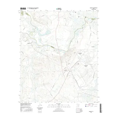
2016 Map of Karnack
USGS Topo · Published 2016About this map
Caddo Lake and the complex wetlands of the Big Cypress Bayou dominate this East Texas landscape along the border of Marion and Harrison counties. The map captures the intricate network of sloughs, chutes, and lakes that define the region, including Stumpie Lake, Littletons Lake, and the expansive Big Four Slough. The industrial presence of the Longhorn AAP occupies a significant portion of the terrain east of Karnack, with its extensive road network and proximity to the Wildlife Observation Trail.
Find a feature on this map
84 named features on this map. Tap any name to fly to it.
Don’t see what you’re looking for? This feature index may not catch every label — zoom into the map to look around manually.
Map Details
Editions of this 2016 Karnack Map
This is the sole edition of this map. No revisions or reprints were ever made.
Other maps of this area

1944 · Kildare
USGS Topo · 1:62,500

1944 · Caddo Lake
USGS Topo · 1:62,500

1946 · Caddo Lake
USGS Topo · 1:62,500

1948 · Kildare
USGS Topo · 1:62,500

1956 · Tyler
USGS Topo · 1:250,000
1962 · Trees
USGS Topo · 1:24,000

1962 · Woodlawn
USGS Topo · 1:24,000
1962 · Smithland
USGS Topo · 1:24,000

1962 · Jefferson
USGS Topo · 1:24,000
1962 · Potters Point
USGS Topo · 1:24,000