
1962 Map of Jefferson
USGS Topo · Published 1963About this map
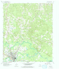
The riverfront city of Jefferson serves as the focal point of this 1960s survey, situated at the confluence where Big Cypress Bayou meets Black Cypress Bayou. The map documents the city's established street grid, including its educational and religious foundations such as Central High Sch and Oakwood Cem. This era shows a landscape where historic river commerce was superseded by a dense network of energy and rail infrastructure, evidenced by multiple Pipelines, a Refinery, and the tracks of the Texas and Pacific and Louisiana and Arkansas railroads.
Find a feature on this map
31 named features on this map. Tap any name to fly to it.
Don’t see what you’re looking for? This feature index may not catch every label — zoom into the map to look around manually.
Map Details
Editions of this 1962 Jefferson Map
2 editions found
Other maps of this area

1944 · Kildare
USGS Topo · 1:62,500

1944 · Caddo Lake
USGS Topo · 1:62,500

1946 · Caddo Lake
USGS Topo · 1:62,500

1948 · Kildare
USGS Topo · 1:62,500

1956 · Tyler
USGS Topo · 1:250,000

1961 · Cunningham Creek
USGS Topo · 1:24,000

1962 · Kellyville
USGS Topo · 1:24,000

1962 · Lanier
USGS Topo · 1:24,000

1962 · Marshall NW
USGS Topo · 1:24,000

1962 · Woodlawn
USGS Topo · 1:24,000