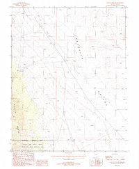
1987 Map of Kawich Peak NE
USGS Topo · Published 1988About this map
Reveille Valley dominates the central portion of this 1980s topographic survey, bordered to the west by the steep rising slopes of the Kawich Range. This high desert landscape is characterized by its isolation and specialized land use, primarily serving as a Restricted Access Area within the Nellis Air Force Range. The map reveals evidence of both natural management and historic human utility, noting the Nevada Wild Horse Management Area alongside a scattered Aqueduct and a remote Corral. Occasional industrial traces appear in the form of a prospect, reflecting the region's mining heritage. Surveyors have also carefully marked the Base Line and township boundaries, providing a precise grid for this section of Nye County where open range and military restricted zones meet.
Find a feature on this map
16 named features on this map. Tap any name to fly to it.
Don’t see what you’re looking for? This feature index may not catch every label — zoom into the map to look around manually.
Map Details
Editions of this 1987 Kawich Peak NE Map
This is the sole edition of this map. No revisions or reprints were ever made.
Other maps of this area

1908 · Kawich
USGS Topo · 1:250,000

1942 · Reveille Peak
USGS Topo · 1:125,000

1952 · Kawich Peak
USGS Topo · 1:62,500

1952 · Reveille Peak
USGS Topo · 1:62,500

1954 · Goldfield
USGS Topo · 1:250,000

1955 · Goldfield
USGS Topo · 1:250,000

1956 · Tonopah
USGS Topo · 1:250,000

1958 · Goldfield
USGS Topo · 1:250,000

1959 · Tonopah
USGS Topo · 1:250,000

1962 · Goldfield
USGS Topo · 1:250,000