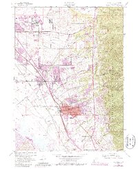
1955 Map of Kaysville
USGS Topo · Published 1987About this map
Hill Air Force Base dominates the northern landscape of this survey, marking a period of significant military and industrial expansion in Davis County. The transportation network is remarkably dense, featuring three major rail lines: the Union Pacific, the Denver and Rio Grande Western, and the Bamberger RR, which served the growing corridor between Clearfield and Farmington. A notable industrial landmark is the Sugar Factory near West Layton, reflecting the area's agricultural processing roots alongside newer developments like Sahara Village.
Find a feature on this map
61 named features on this map. Tap any name to fly to it.
Don’t see what you’re looking for? This feature index may not catch every label — zoom into the map to look around manually.
Map Details
Editions of this 1955 Kaysville Map
4 editions found

Other maps of this area

1885 · Salt Lake
USGS Topo · 1:250,000

1885 · Tooele Valley
USGS Topo · 1:250,000

1925 · Ft. Douglas
USGS Topo · 1:125,000

1928 · Ft. Douglas
USGS Topo · 1:125,000

1952 · Saltair NE
USGS Topo · 1:24,000

1952 · Farmington
USGS Topo · 1:24,000

1952 · Bountiful Peak
USGS Topo · 1:24,000

1953 · Tooele
USGS Topo · 1:250,000

1954 · Salt Lake City
USGS Topo · 1:250,000

1954 · Ogden
USGS Topo · 1:250,000