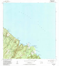
1983 Map of Keanae
USGS Topo · Published 1983About this map
Keanae and Wailua anchor this coastal segment of East Maui, where traditional land divisions meet 20th-century infrastructure. The landscape is defined by the steep valleys of the Koolau Forest Reserve and the complex water-management system of the Koolau Ditch, which traverses the terrain via a series of tunnels and penstocks. Along the coast, the Keanae Homesteads and Wailua Homesteads reflect local land use patterns established long before the Hana Highway modernized access to the region.
Find a feature on this map
75 named features on this map. Tap any name to fly to it.
Don’t see what you’re looking for? This feature index may not catch every label — zoom into the map to look around manually.
Map Details
Editions of this 1983 Keanae Map
This is the sole edition of this map. No revisions or reprints were ever made.
Other maps of this area

1954 · Maui
USGS Topo · 1:250,000

1957 · Kilohana
USGS Topo · 1:24,000

1957 · Hana
USGS Topo · 1:24,000

1957 · Haiku
USGS Topo · 1:24,000

1957 · Nahiku
USGS Topo · 1:24,000

1957 · Keanae
USGS Topo · 1:24,000

1966 · Maui
USGS Topo · 1:250,000

1974 · Maui
USGS Topo · 1:250,000

1978 · Hana
USGS Topo · 1:24,000

1983 · Nahiku
USGS Topo · 1:24,000