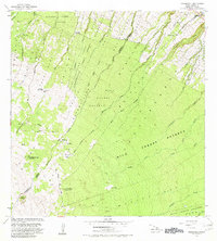
1982 Map of Keanakolu
USGS Topo · Published 1982About this map
The Doctor David Douglas Historical Monument (Kaluakauka) stands as a notable landmark in this upland region of Hawaii, marking the site where the famed botanist perished. This 1982 survey illustrates a landscape defined by forest management and homesteading patterns along the slopes of the Mauna Kea foothills. A series of remote outposts, including the Keanakolu Ranger Station, Puu Loa No 2 Camp, and Iolehaehae Camp, provide structure to the vast stretches of the Hamakua Forest Reserve and Hilo Forest Reserve. The map details a complex system of gulches, such as Kaula Gulch and Kupapaulua Gulch, which drain the volcanic terrain toward the coast. Historical land divisions are clearly marked through the presence of the Niupea Homesteads and Waipunalei Homesteads, reflecting the era's agricultural and settlement boundaries.
Find a feature on this map
38 named features on this map. Tap any name to fly to it.
Don’t see what you’re looking for? This feature index may not catch every label — zoom into the map to look around manually.
Map Details
Editions of this 1982 Keanakolu Map
This is the sole edition of this map. No revisions or reprints were ever made.
Other maps of this area

1915 · Hamakua
USGS Topo · 1:62,500

1915 · Honomu
USGS Topo · 1:62,500

1954 · Hawaii North
USGS Topo · 1:250,000

1956 · Pua Akala
USGS Topo · 1:24,000

1956 · Keanakolu
USGS Topo · 1:24,000

1956 · Mauna Kea
USGS Topo · 1:24,000

1956 · Umikoa
USGS Topo · 1:24,000

1957 · Kukaiau
USGS Topo · 1:24,000

1957 · Honokaa
USGS Topo · 1:24,000

1959 · Hawaii North
USGS Topo · 1:250,000