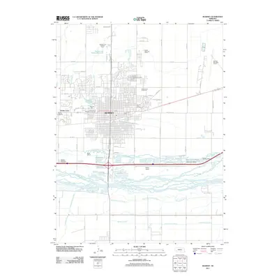
2011 Map of Kearney
USGS Topo · Published 2011About this map
The braided channels of the Platte River dominate the southern landscape of Kearney, creating a complex network of islands and waterways such as Black Island, Evarts Island, and Governor Island. The city itself is anchored by the University of Nebraska at Kearney, with the urban grid extending toward the Buffalo County Fairgrounds and the Kearney Drive-In Theater. North of the city center, water management and recreation converge at the Staubitz and Holmes Reservoir and the Buffalo Ridge Golf Course. Transportation and infrastructure are central to the area's layout, featuring the Kearney Municipal Airport to the east and the Kearney Rest Area - Westbound along the interstate. Smaller water features like Kea Lake, Whisky Slough, and the Crooked Creek Ditch reflect the region's intricate drainage and irrigation history.
Find a feature on this map
65 named features on this map. Tap any name to fly to it.
Don’t see what you’re looking for? This feature index may not catch every label — zoom into the map to look around manually.
Map Details
Editions of this 2011 Kearney Map
This is the sole edition of this map. No revisions or reprints were ever made.
Other maps of this area

1894 · Kearney
USGS Topo · 1:62,500

1894 · Minden
USGS Topo · 1:62,500

1896 · Kearney
USGS Topo · 1:125,000

1896 · Wood River
USGS Topo · 1:125,000

1955 · Grand Island
USGS Topo · 1:250,000

1957 · Grand Island
USGS Topo · 1:250,000

1958 · Grand Island
USGS Topo · 1:250,000

1962 · Newark
USGS Topo · 1:24,000

1962 · Riverdale
USGS Topo · 1:24,000
1962 · Pleasanton SE
USGS Topo · 1:24,000
Featured Places
- Kearney, NE
- R-Villa Courts, Kearney
- East Lawn Mobile Home Estates, Kearney
- Riverside Mobile Home Court, Kearney
- Valley View Trailer Court, Kearney