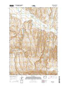
2014 Map of Keating
USGS Topo · Published 2014About this map
Keating serves as the focal point for this rural Baker County landscape, situated near the confluence of the Powder River and its various irrigation networks. The map details a complex system of water management essential to the high desert valley, featuring the Duncan Ditch, Cranston Ditch, Basche Ditch, and Perkins Ditch which trace the contours of the terrain to support local agriculture. To the south, the topography rises sharply from Lower Powder Valley toward Sawtooth Ridge, a transition from irrigated bottomlands to the rugged uplands. Small-scale water storage is evident at Love Reservoir and the nearby Constance Reservoir, reflecting the historical and ongoing importance of water rights and land use in this part of eastern Oregon. Further south, the high plateau of Pritchard Flat and the drainage of Ritter Creek define the geography before the land descends toward the Eagle Valley region.
Find a feature on this map
2 named features on this map. Tap any name to fly to it.
Don’t see what you’re looking for? This feature index may not catch every label — zoom into the map to look around manually.
Map Details
Editions of this 2014 Keating Map
This is the sole edition of this map. No revisions or reprints were ever made.
Other maps of this area

1901 · Baker City
USGS Topo · 1:125,000

1915 · Pine
USGS Topo · 1:125,000

1955 · Baker
USGS Topo · 1:250,000

1957 · Sparta
USGS Topo · 1:62,500

1957 · Durkee
USGS Topo · 1:62,500

1959 · Baker
USGS Topo · 1:250,000
1967 · Sawtooth Ridge
USGS Topo · 1:24,000

1967 · Virtue Flat
USGS Topo · 1:24,000

1967 · Encina
USGS Topo · 1:24,000
1967 · Keating
USGS Topo · 1:24,000