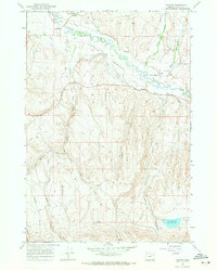
1967 Map of Keating
USGS Topo · Published 1971About this map
The Lower Powder Valley is the focal point of this 1967 survey, where the winding Powder River supports a complex irrigation network of historical water rights and infrastructure. Small settlements like Keating and Middle Bridge serve as the anchors for this agricultural landscape, connected by numerous named canals including the Basche Duncan Ditch, Cranston Ditch, and Perkins Ditch. The presence of the Grange Hall near the river bank highlights the area's rural social fabric during the late 1960s.
Find a feature on this map
31 named features on this map. Tap any name to fly to it.
Don’t see what you’re looking for? This feature index may not catch every label — zoom into the map to look around manually.
Map Details
Editions of this 1967 Keating Map
This is the sole edition of this map. No revisions or reprints were ever made.
Other maps of this area

1901 · Baker City
USGS Topo · 1:125,000

1915 · Pine
USGS Topo · 1:125,000

1955 · Baker
USGS Topo · 1:250,000

1957 · Sparta
USGS Topo · 1:62,500

1957 · Durkee
USGS Topo · 1:62,500

1959 · Baker
USGS Topo · 1:250,000
1967 · Sawtooth Ridge
USGS Topo · 1:24,000

1967 · Virtue Flat
USGS Topo · 1:24,000

1967 · Encina
USGS Topo · 1:24,000
1967 · Keating NW
USGS Topo · 1:24,000