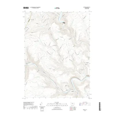
2019 Map of Keating
USGS Topo · Published 2019About this map
Sinnemahoning Creek flows southeastward through a deeply dissected plateau to its confluence with the West Branch Susquehanna River at the small settlement of Keating. This region of Clinton County is defined by a complex network of steep hollows and narrow ridges, such as Bushley Ridge and Savage Mtn. The map documents the presence of Bitumen and Cooks Run, along with the Saint Marys Catholic Cem perched on a high bench overlooking the river valley. The landscape is heavily marked by forestry and early industrial access roads like Cole Run Rd and Renovo Rd. In the north, Kettle Creek Lake occupies the valley bottom, surrounded by numerous named drainages including Summerson Run and Honey Run. These watercourses and their associated hollows, like Wildcat Hollow and Buckhorn Hollow, illustrate the intricate drainage patterns that have shaped the central Pennsylvania highlands.
Find a feature on this map
88 named features on this map. Tap any name to fly to it.
Don’t see what you’re looking for? This feature index may not catch every label — zoom into the map to look around manually.
Map Details
Editions of this 2019 Keating Map
This is the sole edition of this map. No revisions or reprints were ever made.
Other maps of this area

1928 · Snow Shoe
USGS Topo · 1:48,000

1929 · Karthaus
USGS Topo · 1:62,500

1931 · Show Shoe
USGS Topo · 1:62,500

1932 · Karthaus
USGS Topo · 1:62,500

1945 · Driftwood
USGS Topo · 1:48,000

1945 · First Fork
USGS Topo · 1:24,000

1945 · Sinnemahoning
USGS Topo · 1:24,000

1946 · Renovo West
USGS Topo · 1:62,500

1946 · Hammersley Fork
USGS Topo · 1:24,000

1946 · Keating
USGS Topo · 1:24,000
Featured Places
- Leidy Township, PA
- East Keating Township, PA
- Bitumen, Noyes Township
- Keating, East Keating Township
- Burnside Township, PA