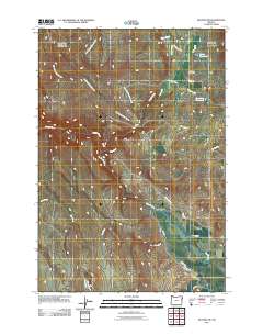
2011 Map of Keating NW
USGS Topo · Published 2011About this map
The Powder River meanders through this portion of eastern Oregon, defining a landscape shaped by early 21st-century agricultural water management. A complex network of irrigation infrastructure is visible, including the Kennedy Ditch, Emelie Ditch, and Basche Ditch, which redirect water across the valley floor. These human-made channels intersect with natural drainages like Big Rattlesnake Creek and Beagle Creek, illustrating the intensive ranching and farming character of the region. Local heritage is grounded at the Big Creek Cemetery and crossings such as Miles Bridge. Named roads like Wirth Rd and Gene Harsin Rd link family-named reservoirs, including Wirth Reservoir and Homesite Reservoir, to the broader transport network of Miles Bridge Rd.
Find a feature on this map
26 named features on this map. Tap any name to fly to it.
Don’t see what you’re looking for? This feature index may not catch every label — zoom into the map to look around manually.
Map Details
Editions of this 2011 Keating NW Map
This is the sole edition of this map. No revisions or reprints were ever made.
Other maps of this area

1901 · Baker City
USGS Topo · 1:125,000

1906 · Telocaset
USGS Topo · 1:125,000

1955 · Baker
USGS Topo · 1:250,000

1955 · Grangeville
USGS Topo · 1:250,000

1959 · Baker
USGS Topo · 1:250,000

1959 · Grangeville
USGS Topo · 1:250,000

1965 · Flagstaff Butte
USGS Topo · 1:24,000

1965 · Medical Springs
USGS Topo · 1:24,000
1965 · Telocaset
USGS Topo · 1:24,000
1967 · Sawtooth Ridge
USGS Topo · 1:24,000