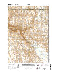
2017 Map of Keating NW
USGS Topo · Published 2017About this map
The Lower Powder Valley serves as a primary geographical focus of this 2017 survey, where the Powder River meanders through a landscape defined by an intricate network of irrigation and water management features. This rural corridor near the Union Co Baker Co line reveals a reliance on engineered water transport, with the Kennedy Ditch, Emele Ditch, Big Cr Ditch, and Erwin Ditch all drawing from the local watershed to support the valley's land use.
Find a feature on this map
33 named features on this map. Tap any name to fly to it.
Don’t see what you’re looking for? This feature index may not catch every label — zoom into the map to look around manually.
Map Details
Editions of this 2017 Keating NW Map
This is the sole edition of this map. No revisions or reprints were ever made.
Other maps of this area

1901 · Baker City
USGS Topo · 1:125,000

1906 · Telocaset
USGS Topo · 1:125,000

1955 · Baker
USGS Topo · 1:250,000

1955 · Grangeville
USGS Topo · 1:250,000

1959 · Baker
USGS Topo · 1:250,000

1959 · Grangeville
USGS Topo · 1:250,000

1965 · Flagstaff Butte
USGS Topo · 1:24,000

1965 · Medical Springs
USGS Topo · 1:24,000
1965 · Telocaset
USGS Topo · 1:24,000
1967 · Sawtooth Ridge
USGS Topo · 1:24,000