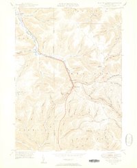
1950 Map of Keating Summit
USGS Topo · Published 1950About this map
Keating Summit and the surrounding high country of the Allegheny Plateau define this 1950 landscape, where the Pennsylvania Railroad follows the winding path of Portage Creek. The map documents a critical drainage divide between the Allegheny River and Sinnemahoning Creek, showing the network of hollows and runs that supported small communities like Liberty, Wrights, and Odin.
Find a feature on this map
62 named features on this map. Tap any name to fly to it.
Don’t see what you’re looking for? This feature index may not catch every label — zoom into the map to look around manually.
Map Details
Editions of this 1950 Keating Summit Map
2 editions found
Other maps of this area

1933 · Smethport
USGS Topo · 1:62,500

1934 · Coudersport
USGS Topo · 1:48,000

1937 · Smethport
USGS Topo · 1:62,500

1938 · Coudersport
USGS Topo · 1:62,500

1948 · Crosby
USGS Topo · 1:62,500

1948 · Emporium
USGS Topo · 1:62,500

1948 · Keating Summit
USGS Topo · 1:24,000

1948 · Emporium
USGS Topo · 1:24,000
1948 · Wharton
USGS Topo · 1:24,000

1948 · Rich Valley
USGS Topo · 1:24,000
Featured Places
- Liberty Township, PA
- Roulette Township, PA
- Norwich Township, PA
- Portage Township, PA
- Keating Township, PA