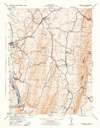
1944 Map of Keddysville
USGS Topo · Published 1944About this map
Antietam National Cemetery and the surrounding Sharpsburg countryside define this wartime landscape, captured just as the Soil Conservation Service and the War Department coordinated mapping for military readiness. The terrain is structured by the sharp rise of South Mountain to the east and the winding course of Antietam Creek to the west. Evidence of the region’s nineteenth-century infrastructure remains prominent, from the Chesapeake and Ohio Canal following the Potomac River to the Baltimore and Ohio railroad connecting small rural hubs like Rohrersville Station and Keedysville. Local life is anchored by family-named landmarks and small crossroads such as Eakles Mill, Zittlestown, and Mt Briar. The map also preserves early 20th-century recreational and navigational markers, including the Appalachian Trail ridge walk and several towers like the USFS Lookout Tower and the Lambs Knoll station.
Find a feature on this map
56 named features on this map. Tap any name to fly to it.
Don’t see what you’re looking for? This feature index may not catch every label — zoom into the map to look around manually.
Map Details
Editions of this 1944 Keddysville Map
2 editions found
Other maps of this area

1884 · Harpers Ferry
USGS Topo · 1:125,000

1891 · Harpers Ferry
USGS Topo · 1:125,000

1893 · Harpers Ferry
USGS Topo · 1:125,000

1908 · Middletown
USGS Topo · 1:48,000

1909 · Hagerstown
USGS Topo · 1:48,000

1910 · Antietam
USGS Topo · 1:62,500

1912 · Hagerstown
USGS Topo · 1:62,500

1912 · Williamsport
USGS Topo · 1:62,500

1914 · Martinsburg
USGS Topo · 1:48,000

1916 · Martinsburg
USGS Topo · 1:62,500