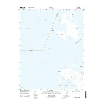
2014 Map of Kedges Straits
USGS Topo · Published 2014About this map
Smith Island and its northern neighbors anchor this maritime survey where the Chesapeake Bay meets Tangier Sound. The landscape is defined by an intricate network of marshes and tidal guts, including the expansive Big Thorofare and Fishing Creek. These wetlands are dotted with family-named landmarks and landforms such as Joes Ridge, Maddox Island, and Noah Ridge. The map illustrates the precarious nature of the Chesapeake’s low-lying landmasses, featuring fragmented islands like Holland Island and Pry Island that sit isolated among the Holland Straits. The boundary between Dorchester Co and Somerset Co cuts across open water and salt marsh, marking a historical line through a region defined more by its nautical passages like Kedges Straits than by solid ground. This survey provides a precise look at the shifting shorelines of Cherry Island and the smaller outcrops of Swan Island and Boat Island as they appeared in the early 21st century.
Find a feature on this map
54 named features on this map. Tap any name to fly to it.
Don’t see what you’re looking for? This feature index may not catch every label — zoom into the map to look around manually.
Map Details
Editions of this 2014 Kedges Straits Map
This is the sole edition of this map. No revisions or reprints were ever made.
Other maps of this area

1898 · St. Marys
USGS Topo · 1:125,000

1903 · Crisfield
USGS Topo · 1:62,500

1903 · Bloodsworth Island
USGS Topo · 1:62,500

1903 · Deal Island
USGS Topo · 1:62,500

1906 · St. Marys
USGS Topo · 1:125,000

1917 · Ewell
USGS Topo · 1:62,500

1920 · Crisfield
USGS Topo · 1:62,500

1942 · Terrapin Sand Point
USGS Topo · 1:24,000

1942 · Kedges Straits
USGS Topo · 1:24,000

1942 · Ewell
USGS Topo · 1:24,000