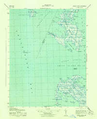
1943 Map of Kedges Straits
USGS Topo · Published 1943About this map
Holland Island and the sprawling wetlands of the South Marsh Island complex dominate this maritime survey of the lower Chesapeake. The landscape is defined by a dense network of tidal guts and coves, such as Pungers Cove and Pry Cove, where the land seems to dissolve into Tangier Sound. Navigation in these shallow waters is marked by critical aids like the Holland Island Bar Lighthouse and the Solomons Lump Lighthouse.
Find a feature on this map
67 named features on this map. Tap any name to fly to it.
Don’t see what you’re looking for? This feature index may not catch every label — zoom into the map to look around manually.
Map Details
Editions of this 1943 Kedges Straits Map
This is the sole edition of this map. No revisions or reprints were ever made.
Other maps of this area

1898 · St. Marys
USGS Topo · 1:125,000

1903 · Crisfield
USGS Topo · 1:62,500

1903 · Bloodsworth Island
USGS Topo · 1:62,500

1903 · Deal Island
USGS Topo · 1:62,500

1906 · St. Marys
USGS Topo · 1:125,000

1917 · Ewell
USGS Topo · 1:62,500

1920 · Crisfield
USGS Topo · 1:62,500

1942 · Terrapin Sand Point
USGS Topo · 1:24,000

1942 · Kedges Straits
USGS Topo · 1:24,000

1942 · Ewell
USGS Topo · 1:24,000