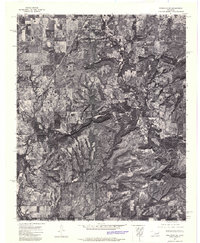
1972 Map of Keefeton SW
USGS Topo · Published 1974About this map
Oktaha and the historic community of Rentiesville anchor this orthophotomosaic of eastern Oklahoma as it appeared in the early 1970s. The map illustrates a distinctive transition between organized agricultural grids and the more complex terrain of the Rattlesnake Mountains. Because this is an orthophotoquad, it provides a rare photographic view of the landscape's texture, showing the exact distribution of timber and cleared pastures that topographic lines alone often obscure. The drainage patterns of Dirty Creek and Butler Creek are clearly visible, winding through the countryside and defining the natural boundaries of the local ranching and farming operations. This imagery is particularly valuable for researchers tracing the physical development of the area before modern land-use changes altered the rural character of these Muskogee County settlements.
Find a feature on this map
5 named features on this map. Tap any name to fly to it.
Don’t see what you’re looking for? This feature index may not catch every label — zoom into the map to look around manually.
Map Details
Editions of this 1972 Keefeton SW Map
This is the sole edition of this map. No revisions or reprints were ever made.
Other maps of this area

1896 · Okmulgee
USGS Topo · 1:125,000

1900 · Sansbois
USGS Topo · 1:125,000

1900 · Canadian
USGS Topo · 1:125,000

1900 · Okmulgee
USGS Topo · 1:125,000

1901 · Muscogee
USGS Topo · 1:125,000

1905 · Muscogee
USGS Topo · 1:125,000

1909 · Sans Bois
USGS Topo · 1:125,000

1911 · Sansbois
USGS Topo · 1:125,000

1946 · Fort Smith
USGS Topo · 1:250,000

1948 · Keefeton
USGS Topo · 1:62,500