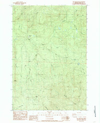
1984 Map of Keel Mountain
USGS Topo · Published 1985About this map
Snow Peak Camp sits at the high-elevation center of this 1980s landscape in Linn County, where timber extraction and high-country hydrology define the terrain. The map reveals an extensive network of resource management, marked by numerous Quarry and Borrow Pit sites scattered across the ridges. A complex watershed system feeds the drainage of Crabtree Creek, with tributaries like White Rock Creek and South Fork Crabtree Creek carving deep into the mountainsides. Significant landmarks such as Keel Mountain, Bald Mountain, and the prominent Lost Dog Rock provide essential orientation for this remote section of the Cascades. Notable for its lack of permanent towns, the area is instead traversed by a web of 4WD trails, serving the rugged industrial and recreational needs of the era near Billy Lake.
Find a feature on this map
61 named features on this map. Tap any name to fly to it.
Don’t see what you’re looking for? This feature index may not catch every label — zoom into the map to look around manually.
Map Details
Editions of this 1984 Keel Mountain Map
This is the sole edition of this map. No revisions or reprints were ever made.
Other maps of this area

1929 · Mill City
USGS Topo · 1:125,000

1934 · Mc Kenzie Bridge
USGS Topo · 1:96,000

1940 · Mc Kenzie Bridge
USGS Topo · 1:125,000

1951 · Sweet Home
USGS Topo · 1:62,500

1951 · Snow Peak
USGS Topo · 1:62,500

1953 · Salem
USGS Topo · 1:250,000

1954 · Salem
USGS Topo · 1:250,000

1955 · Cascadia
USGS Topo · 1:62,500

1956 · Quartzville
USGS Topo · 1:62,500

1960 · Salem
USGS Topo · 1:250,000