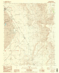
1987 Map of Keeler
USGS Topo · Published 1987About this map
Keeler stands at the western edge of this survey, where the dry expanse of the Owens Valley meets the rising slopes of the Inyo Mts. The map documents a landscape heavily shaped by mineral extraction and water management, featuring numerous prospects, a mine, and extensive tailings near the settlement. Cultural markers like a water tower, corral, and ruins indicate the infrastructure of this arid region, while a local Cem offers a specific point of interest for genealogists tracking early residents. To the east, the terrain becomes increasingly complex as the elevation climbs toward Conglomerate Mesa and the dark volcanic features of Malpais Mesa. This late-twentieth-century study captures the intersection of desert industry and the natural barriers of the Inyo range, preserved during a period of ongoing geologic evaluation.
Find a feature on this map
22 named features on this map. Tap any name to fly to it.
Don’t see what you’re looking for? This feature index may not catch every label — zoom into the map to look around manually.
Map Details
Editions of this 1987 Keeler Map
2 editions found
Other maps of this area

1908 · Ballarat
USGS Topo · 1:250,000

1913 · Ballarat
USGS Topo · 1:250,000

1948 · Death Valley
USGS Topo · 1:250,000

1950 · Darwin
USGS Topo · 1:62,500

1950 · New York Butte
USGS Topo · 1:62,500

1950 · Ubehebe Peak
USGS Topo · 1:62,500

1951 · New York Butte
USGS Topo · 1:62,500

1951 · Darwin
USGS Topo · 1:62,500

1951 · Ubehebe Peak
USGS Topo · 1:62,500

1951 · Keeler
USGS Topo · 1:62,500