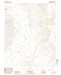
1987 Map of Keeler
USGS Topo · Published 1987About this map
The settlement of Keeler sits at the edge of the expansive Owens Lake bed, a site defined by the extraction and transport of local minerals in the late twentieth century. This 1987 survey illustrates the industrial footprint of the region, where numerous Prospect and Prospects sites dot the rising terrain of the Inyo Mts to the east. Evidence of mining operations is clear through labels for a Mine, Borrow Pit, and Talings, while a system of Levees and a lone Corral suggest the management of both water and livestock in this arid environment. Genealogy researchers will find the local Cem near the townsite, situated between the lake's margin and the high reaches of Malpais Mesa. The map captures a landscape of transition, from the low flats of Owens Valley to the steep, 4WD-accessible slopes of Conglomerate Mesa.
Find a feature on this map
20 named features on this map. Tap any name to fly to it.
Don’t see what you’re looking for? This feature index may not catch every label — zoom into the map to look around manually.
Map Details
Editions of this 1987 Keeler Map
2 editions found
Other maps of this area

1908 · Ballarat
USGS Topo · 1:250,000

1913 · Ballarat
USGS Topo · 1:250,000

1948 · Death Valley
USGS Topo · 1:250,000

1950 · Darwin
USGS Topo · 1:62,500

1950 · New York Butte
USGS Topo · 1:62,500

1950 · Ubehebe Peak
USGS Topo · 1:62,500

1951 · New York Butte
USGS Topo · 1:62,500

1951 · Darwin
USGS Topo · 1:62,500

1951 · Ubehebe Peak
USGS Topo · 1:62,500

1951 · Keeler
USGS Topo · 1:62,500