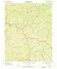
1968 Map of Keen Mountain
USGS Topo · Published 1972About this map
Keen Mountain defines this central portion of the Appalachian coalfields, where the industrial landscape of the late 1960s is etched into every hollow and ridge. The Norfolk and Western railway threads through the valley of Dismal Creek, serving a dense network of extraction sites including several labeled Strip Mines, Tipples, and an Air Shaft. These operations exist alongside long-established mountain communities such as Pilgrims Knob and Grimsleyville, where local life centered on the Bethany Ch and small rural institutions like Contrary Sch.
Find a feature on this map
91 named features on this map. Tap any name to fly to it.
Don’t see what you’re looking for? This feature index may not catch every label — zoom into the map to look around manually.
Map Details
Editions of this 1968 Keen Mountain Map
3 editions found
Other maps of this area

1886 · Grundy
USGS Topo · 1:125,000

1890 · Grundy
USGS Topo · 1:125,000

1891 · Tazewell
USGS Topo · 1:125,000

1892 · Grundy
USGS Topo · 1:125,000

1895 · Tazewell
USGS Topo · 1:125,000

1897 · Tazewell
USGS Topo · 1:125,000

1910 · Iaeger
USGS Topo · 1:48,000

1912 · Iaeger
USGS Topo · 1:62,500

1914 · Bucu
USGS Topo · 1:48,000

1914 · Iaeger
USGS Topo · 1:48,000