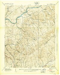
1938 Map of Keenburg
USGS Topo · Published 1938About this map
The South Fork Holston River winds through the northern reaches of this territory, defining a landscape of hollows and ridges just before the creation of the massive regional reservoirs. Near the river, local life centered around small gatherings at Rock Hole Ch and the rural community of Silver Grove. To the south, the terrain rises sharply into the Cherokee National Forest, dominated by the massive bulk of Holston Mountain and the high point of Grandfather Knob.
Find a feature on this map
102 named features on this map. Tap any name to fly to it.
Don’t see what you’re looking for? This feature index may not catch every label — zoom into the map to look around manually.
Map Details
Editions of this 1938 Keenburg Map
2 editions found
Other maps of this area

1891 · Roan Mountain
USGS Topo · 1:125,000

1894 · Roan Mountain
USGS Topo · 1:125,000

1897 · Bristol
USGS Topo · 1:125,000

1902 · Bristol
USGS Topo · 1:125,000

1904 · Roan Mountain
USGS Topo · 1:125,000

1934 · Holston Valley
USGS Topo · 1:24,000

1934 · Bristol
USGS Topo · 1:24,000

1935 · Watauga Valley
USGS Topo · 1:48,000

1935 · Blountville
USGS Topo · 1:24,000
1935 · Carter
USGS Topo · 1:24,000