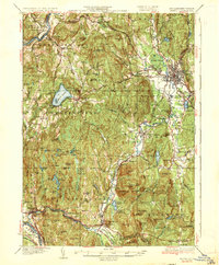
1935 Map of Keene
USGS Topo · Published 1935About this map
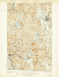
The Connecticut River forms the western boundary of this 1930s landscape, where the Boston and Maine RR and Central Vermont RR trace the valley floor. Settlement is concentrated in the bustling hub of Keene and along the winding Ashuelot River, which connects mill towns like Ashuelot and Winchester. The terrain is defined by significant elevations such as Pisgah Mountain and Mt Cresson, while recreational and conservation interests are evident at Spofford Lake and the Richmond Trout Rearing Station. Local education and civic life are anchored by landmarks like the Superior Sch and the historic Meetinghouse Hill. The map illustrates a rural New England economy transitioning from its industrial river-power roots, with State Highway No 9 beginning to reshape the movement of goods and people between these Cheshire County townships.
Find a feature on this map
122 named features on this map. Tap any name to fly to it.
Don’t see what you’re looking for? This feature index may not catch every label — zoom into the map to look around manually.
Map Details
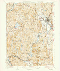
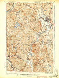
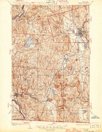
Editions of this 1935 Keene Map
5 editions found
Other maps of this area

1887 · Warwick
USGS Topo · 1:62,500

1887 · Winchendon
USGS Topo · 1:62,500

1889 · Warwick
USGS Topo · 1:62,500

1890 · Greenfield
USGS Topo · 1:62,500

1890 · Winchendon
USGS Topo · 1:62,500

1891 · Brattleboro
USGS Topo · 1:62,500

1893 · Brattleboro
USGS Topo · 1:62,500

1894 · Winchendon
USGS Topo · 1:62,500

1894 · Greenfield
USGS Topo · 1:62,500

1894 · Warwick
USGS Topo · 1:62,500