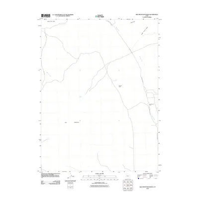
2010 Map of Keg Mountain Ranch
USGS Topo · Published 2010About this map
Keg Mountain Ranch anchors the eastern edge of this Juab County landscape, situated near the intersection of several desert roads and watercourses. The terrain is defined by the prominent Keg Mountain and the Slow Elk Hills to the northwest, with the dry course of the Old River Bed cutting a distinct path through the center of the sheet. This drainage pattern suggests a historical hydrological importance for the area, even in its modern arid state. Remote outposts and landmarks such as Willow Spring and Harvey Knoll provide orientation points for travelers along the Riverbed Ranch Rd and Keg Pass Rd. The map also captures several seasonal drainages, including Dead Ox Creek and Death Canyon Wash, which converge toward the ancient river channel.
Find a feature on this map
12 named features on this map. Tap any name to fly to it.
Don’t see what you’re looking for? This feature index may not catch every label — zoom into the map to look around manually.
Map Details
Editions of this 2010 Keg Mountain Ranch Map
This is the sole edition of this map. No revisions or reprints were ever made.
Other maps of this area

1885 · Sevier Desert
USGS Topo · 1:250,000

1953 · Delta
USGS Topo · 1:250,000

1955 · Indian Springs
USGS Topo · 1:24,000
1955 · Table Mountain
USGS Topo · 1:24,000

1955 · Coyote Springs
USGS Topo · 1:24,000

1958 · Delta
USGS Topo · 1:250,000

1962 · Delta
USGS Topo · 1:250,000

1971 · Picture Rock Hills
USGS Topo · 1:24,000

1971 · Crater Bench Reservoir
USGS Topo · 1:24,000
1971 · Keg Mtn Ranch
USGS Topo · 1:24,000