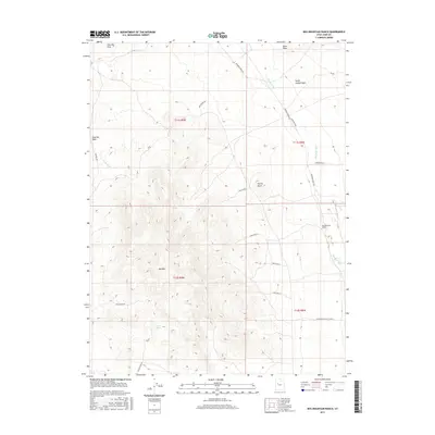
2017 Map of Keg Mountain Ranch
USGS Topo · Published 2017About this map
Keg Mountain Ranch and its surrounding desert topography define this portion of Juab County in the mid-2010s. The landscape is characterized by a complex network of seasonal watercourses and drainage systems, including the notable Old River Bed and the winding Dead Ox Cr. Arid terrain features such as the Slow Elk Hills, Harvey Knoll, and the prominent Keg Mtn dominate the elevation. The map illustrates a history of land use through remote infrastructure, with specialized routes like Keg Mining Rd and Riverbed Ranch Rd connecting isolated springs and mountain passes. Vital water sources in this dry environment, such as Willow Spring and Keg Spring, serve as critical landmarks. This survey provides a precise record of the public land survey system grid, including townships T11S R9W and T12S R8W, which dictate the placement of ranching and mining access roads across the basin.
Find a feature on this map
26 named features on this map. Tap any name to fly to it.
Don’t see what you’re looking for? This feature index may not catch every label — zoom into the map to look around manually.
Map Details
Editions of this 2017 Keg Mountain Ranch Map
This is the sole edition of this map. No revisions or reprints were ever made.
Other maps of this area

1885 · Sevier Desert
USGS Topo · 1:250,000

1953 · Delta
USGS Topo · 1:250,000

1955 · Indian Springs
USGS Topo · 1:24,000
1955 · Table Mountain
USGS Topo · 1:24,000

1955 · Coyote Springs
USGS Topo · 1:24,000

1958 · Delta
USGS Topo · 1:250,000

1962 · Delta
USGS Topo · 1:250,000

1971 · Picture Rock Hills
USGS Topo · 1:24,000

1971 · Crater Bench Reservoir
USGS Topo · 1:24,000
1971 · Keg Mtn Ranch
USGS Topo · 1:24,000