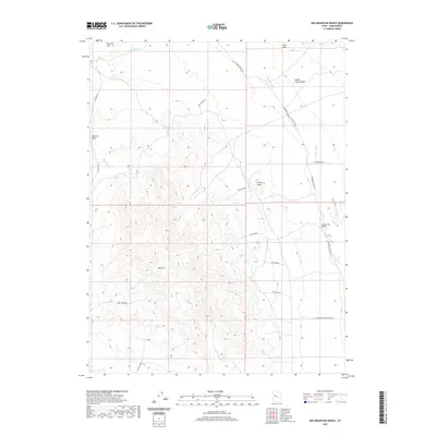
2020 Map of Keg Mountain Ranch
USGS Topo · Published 2020About this map
Keg Mountain Ranch sits within a landscape defined by the drainage patterns of the Old River Bed and the imposing profile of Keg Mtn. This high-desert region in Juab County is characterized by a network of ranching and mining access routes, such as the Keg Mining Rd and Wilson Camp Rd, which navigate the various washes and knolls. Significant water sources in this arid environment are marked by Willow Spring and Keg Spring, which have historically dictated the placement of trails and temporary settlements. The terrain features numerous named landforms including Harvey Knoll, the Slow Elk Hills, and Death Canyon Wash. The layout of modern roads like Riverbed Ranch Rd follows the ancient natural corridor of the riverbed, reflecting how the geology continues to shape contemporary transportation and ranching infrastructure.
Find a feature on this map
23 named features on this map. Tap any name to fly to it.
Don’t see what you’re looking for? This feature index may not catch every label — zoom into the map to look around manually.
Map Details
Editions of this 2020 Keg Mountain Ranch Map
This is the sole edition of this map. No revisions or reprints were ever made.
Other maps of this area

1885 · Sevier Desert
USGS Topo · 1:250,000

1953 · Delta
USGS Topo · 1:250,000

1955 · Indian Springs
USGS Topo · 1:24,000
1955 · Table Mountain
USGS Topo · 1:24,000

1955 · Coyote Springs
USGS Topo · 1:24,000

1958 · Delta
USGS Topo · 1:250,000

1962 · Delta
USGS Topo · 1:250,000

1971 · Picture Rock Hills
USGS Topo · 1:24,000

1971 · Crater Bench Reservoir
USGS Topo · 1:24,000
1971 · Keg Mtn Ranch
USGS Topo · 1:24,000