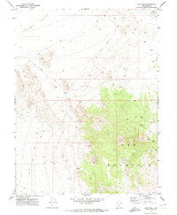
1971 Map of Keg Mtn Pass
USGS Topo · Published 1974About this map
Keg Mountain dominates this high-desert landscape in central Utah, serving as a prominent landmark between the Dugway Valley and the surrounding basin floor. The geography is defined by its arid character, where water sources like Flint Spring, Keg Spring, and a lone Spring at the base of the mountains provided essential stops for travelers and prospectors. Evidence of mineral exploration is present through several Prospects and a singular Prospect located near the southern reaches of the range, indicating the mining interest that often drew people into this difficult environment.
Find a feature on this map
15 named features on this map. Tap any name to fly to it.
Don’t see what you’re looking for? This feature index may not catch every label — zoom into the map to look around manually.
Map Details
Editions of this 1971 Keg Mtn Pass Map
This is the sole edition of this map. No revisions or reprints were ever made.
Other maps of this area

1885 · Sevier Desert
USGS Topo · 1:250,000

1908 · Fish Springs
USGS Topo · 1:250,000

1910 · Fish Springs
USGS Topo · 1:250,000

1953 · Dugway Range NE
USGS Topo · 1:24,000

1953 · Dugway Pass
USGS Topo · 1:24,000

1953 · Dugway Range
USGS Topo · 1:62,500

1953 · Topaz Mtn
USGS Topo · 1:62,500

1953 · Delta
USGS Topo · 1:250,000
1955 · Table Mountain
USGS Topo · 1:24,000

1955 · Coyote Springs
USGS Topo · 1:24,000