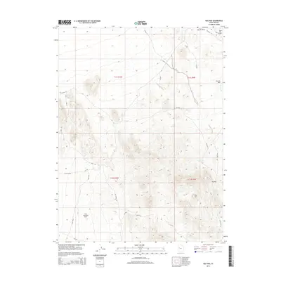
2014 Map of Keg Pass
USGS Topo · Published 2014About this map
Rock Hounding Area stands as a primary point of interest in this arid corridor of Juab County, highlighting the region's draw for mineral collectors and geologists. The landscape is defined by the prominent Keg Mtn and the narrow Keg Pass, which serves as a natural transit point through the high desert terrain. A network of unimproved tracks and washes, such as Keg Mining Rd and Pismire Wash Rd, indicates a history of resource extraction and rugged access. Water, while scarce, is marked by seasonal drainages like Slow Elk Wash and Dead Ox Cr, alongside essential desert water sources including Keg Spring and Flint Spring. This 2014 survey documents the isolated character of the West Desert, where named landforms like the Slow Elk Hills provide critical navigation landmarks for those traversing the public lands between mountain ranges.
Find a feature on this map
30 named features on this map. Tap any name to fly to it.
Don’t see what you’re looking for? This feature index may not catch every label — zoom into the map to look around manually.
Map Details
Editions of this 2014 Keg Pass Map
This is the sole edition of this map. No revisions or reprints were ever made.
Other maps of this area

1885 · Sevier Desert
USGS Topo · 1:250,000

1908 · Fish Springs
USGS Topo · 1:250,000

1910 · Fish Springs
USGS Topo · 1:250,000

1953 · Dugway Range NE
USGS Topo · 1:24,000

1953 · Dugway Pass
USGS Topo · 1:24,000

1953 · Dugway Range
USGS Topo · 1:62,500

1953 · Topaz Mtn
USGS Topo · 1:62,500

1953 · Delta
USGS Topo · 1:250,000
1955 · Table Mountain
USGS Topo · 1:24,000

1955 · Coyote Springs
USGS Topo · 1:24,000