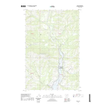
2020 Map of Keller
USGS Topo · Published 2020About this map
Keller sits at the northern confluence of several mountain drainages, serving as a hub for the remote topography of the Colville Indian Reservation. The Sanpoil River carves a deep valley through the center of this terrain, its waters eventually feeding into the Lake Roosevelt National Recreation Area and the Sanpoil River Arm. This 2020 survey illustrates a landscape defined by significant elevation changes, anchored by the prominent Mt Tolman and high ridgelines traced by Johnson Ridge Rd. Access into these drainages is managed by a network of Bureau of Indian Affairs and local routes like Stove Pipe Rd and Manila Creek Rd. The presence of French Johns Lake and numerous creeks such as Meadow Cr and Silver Cr highlights the complex water system that dictates movement and settlement patterns in this part of Ferry County.
Find a feature on this map
36 named features on this map. Tap any name to fly to it.
Don’t see what you’re looking for? This feature index may not catch every label — zoom into the map to look around manually.
Map Details
Editions of this 2020 Keller Map
This is the sole edition of this map. No revisions or reprints were ever made.
Other maps of this area

1948 · Grand Coulee Dam
USGS Topo · 1:62,500

1948 · Wilbur
USGS Topo · 1:62,500

1950 · Wilbur
USGS Topo · 1:62,500

1950 · Grand Coulee Dam
USGS Topo · 1:62,500

1950 · Nespelem
USGS Topo · 1:62,500

1952 · Keller
USGS Topo · 1:62,500

1953 · Ritzville
USGS Topo · 1:250,000

1954 · Okanogan
USGS Topo · 1:250,000

1958 · Okanogan
USGS Topo · 1:250,000

1959 · Ritzville
USGS Topo · 1:250,000