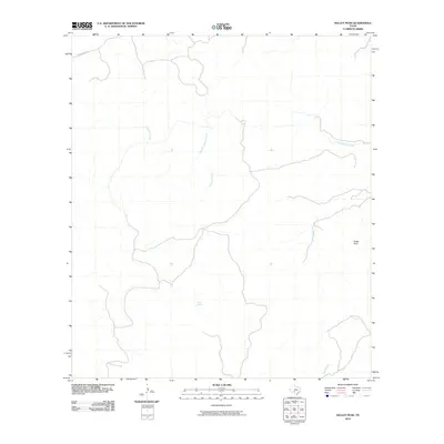
2010 Map of Kelley Peak
USGS Topo · Published 2010About this map
Kelley Peak rises above a landscape defined by an intricate network of intermittent waterways in this section of Edwards County. The terrain is deeply carved by drainage systems, most notably the meandering course of Sycamore Creek and its tributary, Rough Sycamore Creek. This 2010 survey illustrates a sparsely developed ranching or conservation environment where water sources are the primary landmarks. Significant hydrologic features include Pecan Spring and Spring Creek, which serve as vital points of interest in an otherwise arid expanse. Human infrastructure is minimal, represented largely by the winding Cedar Creek Rd in the northwest, suggesting a place of quiet isolation and private landholdings. To the southeast, the terrain falls away toward Lost Creek, completing a picture of a watershed that remains largely untouched by modern urbanization.
Find a feature on this map
8 named features on this map. Tap any name to fly to it.
Don’t see what you’re looking for? This feature index may not catch every label — zoom into the map to look around manually.
Map Details
Editions of this 2010 Kelley Peak Map
This is the sole edition of this map. No revisions or reprints were ever made.
Other maps of this area

1893 · Nueces
USGS Topo · 1:125,000

1896 · Nueces
USGS Topo · 1:125,000

1944 · Barksdale
USGS Topo · 1:62,500

1944 · Indian Creek
USGS Topo · 1:62,500

1944 · Indian Mountain
USGS Topo · 1:62,500

1947 · Hackberry
USGS Topo · 1:62,500

1958 · Del Rio
USGS Topo · 1:250,000

1964 · Del Rio
USGS Topo · 1:250,000
1967 · Indian Mountain
USGS Topo · 1:24,000
1973 · Montell
USGS Topo · 1:24,000