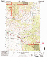
2000 Map of Kelly Creek
USGS Topo · Published 2005About this map
Bridger Range peaks and the eastern edge of Bozeman meet in this 2000 revision, illustrating the expansion of the corporate boundary toward the foothills of Gallatin National Forest. The landscape is defined by the sharp transition from the East Gallatin River valley floor to the steep drainages of Sypes Canyon and Kelly Canyon Creek. In the southern reaches of the map, the industrial and educational history of the area is visible near the settlement of Chestnut, where a Mine and the Mount Ellis Academy sit near the winding path of Rocky Canyon Creek. Further north, the US Fish Culture Development Center and Drinking Horse Mountain highlight the intersection of federal resource management and local topography that characterizes the outskirts of Gallatin County.
Find a feature on this map
28 named features on this map. Tap any name to fly to it.
Don’t see what you’re looking for? This feature index may not catch every label — zoom into the map to look around manually.
Map Details
Editions of this 2000 Kelly Creek Map
This is the sole edition of this map. No revisions or reprints were ever made.
Other maps of this area

1888 · Three Forks
USGS Topo · 1:250,000

1891 · Livingston
USGS Topo · 1:250,000

1893 · Livingston
USGS Topo · 1:250,000

1894 · Three Forks
USGS Topo · 1:250,000

1895 · Three Forks
USGS Topo · 1:250,000

1947 · Bozeman
USGS Topo · 1:250,000

1948 · Bozeman
USGS Topo · 1:250,000

1950 · Belgrade
USGS Topo · 1:62,500

1951 · Bozeman Pass
USGS Topo · 1:62,500

1951 · Sedan
USGS Topo · 1:62,500