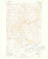
1951 Map of Kelly Hills
USGS Topo · Published 1953About this map
The Yellowstone River cuts through the southern reaches of this landscape, serving as a primary corridor for early transportation and irrigation near the border of Sweet Grass and Park counties. A network of agricultural infrastructure is visible, including a ditch system and flume that directed water from tributaries like Duck Creek and Hunters Creek to support various homesteads. Settlement patterns are defined by established ranching operations such as the Bow Ranch and Cris Bow Ranch, alongside the Old Kelly Homestead (Aband) in the Kelly Hills. Community life is anchored by the Duck Creek School and the Gage Pioneer Memorial, while the historical memory of the area is preserved in names like Sioux Crossing. The map also traces movement through the valley via the Pacific Northern route and several localized lines, including the Prather Mayborn.
Find a feature on this map
39 named features on this map. Tap any name to fly to it.
Don’t see what you’re looking for? This feature index may not catch every label — zoom into the map to look around manually.
Map Details
Editions of this 1951 Kelly Hills Map
3 editions found
Other maps of this area

1891 · Livingston
USGS Topo · 1:250,000

1893 · Livingston
USGS Topo · 1:250,000

1947 · Bozeman
USGS Topo · 1:250,000

1948 · Bozeman
USGS Topo · 1:250,000
1951 · Grosfield Ranch
USGS Topo · 1:24,000
1951 · Raspberry Butte
USGS Topo · 1:24,000

1951 · Kelly Hills
USGS Topo · 1:24,000

1951 · Springdale
USGS Topo · 1:24,000

1951 · Hunters Hot Springs
USGS Topo · 1:24,000

1951 · Elton
USGS Topo · 1:24,000