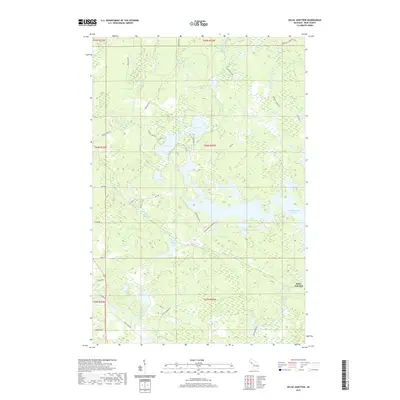
2019 Map of Kelso Junction
USGS Topo · Published 2019About this map
Kelso Junction serves as the primary focal point of this northern Michigan landscape, situated where the waters of the Paint River and the Michigamme Reservoir converge. The area is defined by an intricate network of glacial lakes and wetlands, including Upper Holmes Lake, Polliwog Lake, and the distinctly named Liver Lake. The terrain is crisscrossed by secondary roads and forest tracks like Enstrom Cutoff and Rock Crusher Rd, reflecting the region's historic ties to the timber and mining industries. Small tributaries such as Shenko Cr, McCutcheon Cr, and Saint Paul Cr weave through the forest, feeding into larger systems like the Deer River. Local landmarks like Shoe Pac Lake and family-named routes such as Challancin Landing Rd provide specific points of interest for those tracing the development of Crystal Falls Township.
Find a feature on this map
41 named features on this map. Tap any name to fly to it.
Don’t see what you’re looking for? This feature index may not catch every label — zoom into the map to look around manually.
Map Details
Editions of this 2019 Kelso Junction Map
This is the sole edition of this map. No revisions or reprints were ever made.
Other maps of this area

1895 · Ned Lake
USGS Topo · 1:62,500

1899 · Sagola
USGS Topo · 1:62,500

1899 · Witbeck
USGS Topo · 1:62,500

1899 · Crystal Falls
USGS Topo · 1:62,500

1944 · Crystal Falls
USGS Topo · 1:24,000

1944 · Fortune Lakes
USGS Topo · 1:24,000

1945 · Kelso Junction
USGS Topo · 1:24,000

1945 · Amasa
USGS Topo · 1:24,000

1946 · Crystal Falls
USGS Topo · 1:31,680

1946 · Fortune Lakes
USGS Topo · 1:31,680