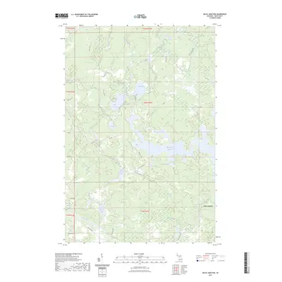
2023 Map of Kelso Junction
USGS Topo · Published 2023About this map
Kelso Junction serves as the focal point of this northern Michigan survey, situated at the confluence of the Kelso River and the Paint River. The landscape is defined by the expansive Michigamme Reservoir, which dominates the central and eastern portions of the sheet. The presence of numerous named water bodies, including Upper Holmes Lake, Lower Holmes Lake, and Liver Lake, suggests a region historically shaped by timber and watershed management. Transport routes like WPA Rd and the Enstrom Cutoff indicate a legacy of infrastructure development in this corner of Iron County. The drainage network is dense, featuring smaller tributaries such as Saint Paul Creek, McCutcheon Creek, and Shaky Creek, which feed the larger river systems and reservoir. This area retains its character as a hub for water-based activity and remote forest access, anchored by the namesake junction and the surrounding wetlands.
Find a feature on this map
41 named features on this map. Tap any name to fly to it.
Don’t see what you’re looking for? This feature index may not catch every label — zoom into the map to look around manually.
Map Details
Editions of this 2023 Kelso Junction Map
This is the sole edition of this map. No revisions or reprints were ever made.
Other maps of this area

1895 · Ned Lake
USGS Topo · 1:62,500

1899 · Sagola
USGS Topo · 1:62,500

1899 · Witbeck
USGS Topo · 1:62,500

1899 · Crystal Falls
USGS Topo · 1:62,500

1944 · Crystal Falls
USGS Topo · 1:24,000

1944 · Fortune Lakes
USGS Topo · 1:24,000

1945 · Kelso Junction
USGS Topo · 1:24,000

1945 · Amasa
USGS Topo · 1:24,000

1946 · Crystal Falls
USGS Topo · 1:31,680

1946 · Fortune Lakes
USGS Topo · 1:31,680