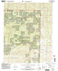
2004 Map of Keltner
USGS Topo · Published 2006About this map
Swan Creek and its many tributaries, including Sugar Camp Creek and Punching Creek, carve through the eastern reaches of the Mark Twain National Forest. This Ozark landscape is defined by its ridge-top navigation and valley-floor settlements like Keltner and Ongo. The map reveals a tight-knit rural geography of family-named cemeteries and community landmarks, such as Harvill Cem and Union Hill Ch, clustered near river fords and spring heads.
Find a feature on this map
43 named features on this map. Tap any name to fly to it.
Don’t see what you’re looking for? This feature index may not catch every label — zoom into the map to look around manually.
Map Details
Editions of this 2004 Keltner Map
This is the sole edition of this map. No revisions or reprints were ever made.
Other maps of this area

1884 · Springfield
USGS Topo · 1:125,000

1886 · Springfield
USGS Topo · 1:125,000

1907 · Forsyth
USGS Topo · 1:125,000

1937 · Bradleyville
USGS Topo · 1:48,000

1937 · Ozark
USGS Topo · 1:48,000

1939 · Fordland
USGS Topo · 1:62,500

1942 · Fordland
USGS Topo · 1:62,500

1943 · Ozark
USGS Topo · 1:62,500

1943 · Bradleyville
USGS Topo · 1:62,500

1945 · Harrison
USGS Topo · 1:250,000