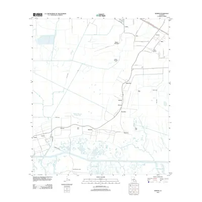
2012 Map of Kemper
USGS Topo · Published 2012About this map
Kilgore Plantation and Home Place anchor this 2012 survey of the southern Louisiana bayou country. The landscape is defined by a dense network of drainage and transportation waterways, including the Iberia-Saint Mary Canal, Patout Canal, and Phillips Canal, which supported the agricultural and industrial needs of the region. Linear settlements such as Freetown, Richland, and Bonvillain follow the roads and higher ground above Hog Bayou and the southern marshlands.
Find a feature on this map
41 named features on this map. Tap any name to fly to it.
Don’t see what you’re looking for? This feature index may not catch every label — zoom into the map to look around manually.
Map Details
Editions of this 2012 Kemper Map
This is the sole edition of this map. No revisions or reprints were ever made.
Other maps of this area

1937 · Bayou Sale
USGS Topo · 1:62,500

1937 · Jeanerette
USGS Topo · 1:62,500

1937 · Derouen
USGS Topo · 1:62,500

1945 · New Orleans
USGS Topo · 1:250,000

1949 · Cypremort Pt
USGS Topo · 1:31,680

1954 · Jeanerette
USGS Topo · 1:62,500

1957 · Bayou Sale
USGS Topo · 1:62,500

1963 · New Orleans
USGS Topo · 1:250,000
1963 · Weeks
USGS Topo · 1:24,000
1963 · Charenton
USGS Topo · 1:24,000