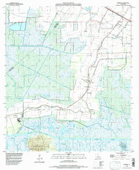
1994 Map of Kemper
USGS Topo · Published 1998About this map
Cote Blanche Island rises distinctly above the coastal wetlands of St. Mary Parish, anchoring a landscape where the Intracoastal Waterway cuts through a dense network of drainage channels and bayous. This mid-1990s survey reflects a region defined by its historic sugar and agricultural heritage, shown through numerous named settlements like Glencoe, Richland, and Kemper that line the banks of Bayou Cypremort. The presence of Kilgore Plantation and St Helens Cem underscores the long-standing community foundations of the area.
Find a feature on this map
35 named features on this map. Tap any name to fly to it.
Don’t see what you’re looking for? This feature index may not catch every label — zoom into the map to look around manually.
Map Details
Editions of this 1994 Kemper Map
This is the sole edition of this map. No revisions or reprints were ever made.
Other maps of this area

1937 · Bayou Sale
USGS Topo · 1:62,500

1937 · Jeanerette
USGS Topo · 1:62,500

1937 · Derouen
USGS Topo · 1:62,500

1945 · New Orleans
USGS Topo · 1:250,000

1949 · Cypremort Pt
USGS Topo · 1:31,680

1954 · Jeanerette
USGS Topo · 1:62,500

1957 · Bayou Sale
USGS Topo · 1:62,500

1963 · New Orleans
USGS Topo · 1:250,000
1963 · Weeks
USGS Topo · 1:24,000
1963 · Charenton
USGS Topo · 1:24,000