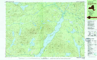
1979 Map of Kempshall Mtn
USGS Topo · Published 1979About this map
Long Lake dominates this central portion of the Adirondack Park in the late 1970s, serving as a focal point for backcountry travel and recreation. The Northville Placid Trail skirts the eastern shore of the lake, passing through Shattuck Clearing and near the Ranger Station as it follows the Raquette River and Cold River corridors. The landscape is defined by high peaks and scattered water bodies, including Kempshall Mtn with its Lookout Tower, and more secluded basins like Mc Rorie Lake and Grampus Lake. Sparse development is limited to isolated landmarks such as the Boy Scout Camp and Island House, reflecting the preservation of the forest character within the Hamilton County and Franklin County boundary region.
Find a feature on this map
71 named features on this map. Tap any name to fly to it.
Don’t see what you’re looking for? This feature index may not catch every label — zoom into the map to look around manually.
Map Details
Editions of this 1979 Kempshall Mtn Map
2 editions found
Other maps of this area

1898 · Newcomb
USGS Topo · 1:62,500

1901 · Newcomb
USGS Topo · 1:62,500

1903 · Raquette Lake
USGS Topo · 1:62,500

1903 · Blue Mountain
USGS Topo · 1:62,500

1904 · Santanoni
USGS Topo · 1:62,500

1904 · Long Lake
USGS Topo · 1:62,500

1907 · Tupper Lake
USGS Topo · 1:62,500

1948 · Ogdensburg
USGS Topo · 1:250,000

1950 · Utica
USGS Topo · 1:250,000

1951 · Ogdensburg
USGS Topo · 1:250,000