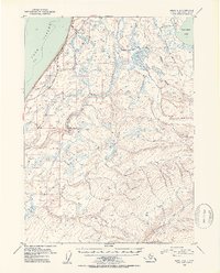
1952 Map of Kenai A-4
USGS Topo · Published 1954About this map
Cook Inlet defines the western edge of this coastal landscape, where the Sterling Highway runs parallel to the shore. This 1952 topographic study captures the early infrastructure of the Kenai Peninsula, anchored by the Clam Gulch Store near the bluffs. Inland, the terrain transitions into the protected wetlands and hills of the Kenai National Moose Range, a massive tract of wilderness bounded by major water systems. The Ninilchik River and its various tributaries, including Clam Creek and Falls Creek, cut across the coastal plain before reaching the inlet. To the northeast, the map details the outlet of Tustumena Lake into the Kasilof River. This record is particularly valuable for its depiction of the Seward Base Line, the fundamental surveying datum that governed the division of land in this part of Alaska during the mid-twentieth century.
Find a feature on this map
15 named features on this map. Tap any name to fly to it.
Don’t see what you’re looking for? This feature index may not catch every label — zoom into the map to look around manually.
Map Details
Editions of this 1952 Kenai A-4 Map
3 editions found

Other maps of this area

1944 · Kenai
USGS Topo · 1:250,000

1946 · Seldovia D-5
USGS Topo · 1:63,360

1949 · Seldovia D-4
USGS Topo · 1:63,360

1950 · Kenai
USGS Topo · 1:250,000

1950 · Kenai B-3
USGS Topo · 1:63,360

1951 · Seldovia D-5
USGS Topo · 1:63,360

1951 · Seldovia D-4
USGS Topo · 1:63,360

1951 · Seldovia
USGS Topo · 1:250,000

1951 · Seldovia D-3
USGS Topo · 1:63,360

1951 · Kenai A-5
USGS Topo · 1:63,360