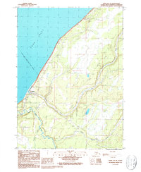
1987 Map of Kenai A-5 SE
USGS Topo · Published 1987About this map
Ninilchik sits along the shores of Cook Inlet, serving as a coastal anchor where the Ninilchik River meets the sea. This 1980s landscape reveals a community shaped by its waterways and transport needs, featuring the Ninilchik Airport and several access points for residents and travelers. The presence of a Cem and Trailer Park near the river mouth indicates a settled population, while the Alaska Maritime National Wildlife Refuge Boundary marks the protected coastal fringes. Moving inland, the terrain is defined by a network of drainage systems including Deep Creek, Salmon Creek, and Silver Creek. Historical land use is further evidenced by a Winter Trail and several Gravel Pits, pointing to local infrastructure development and traditional routes through the Kenai Peninsula interior during the late twentieth century.
Find a feature on this map
19 named features on this map. Tap any name to fly to it.
Don’t see what you’re looking for? This feature index may not catch every label — zoom into the map to look around manually.
Map Details
Editions of this 1987 Kenai A-5 SE Map
This is the sole edition of this map. No revisions or reprints were ever made.
Other maps of this area

1944 · Kenai
USGS Topo · 1:250,000

1946 · Seldovia D-5
USGS Topo · 1:63,360

1949 · Seldovia D-4
USGS Topo · 1:63,360

1950 · Kenai
USGS Topo · 1:250,000

1951 · Seldovia D-5
USGS Topo · 1:63,360

1951 · Seldovia D-4
USGS Topo · 1:63,360

1951 · Seldovia
USGS Topo · 1:250,000

1951 · Kenai A-5
USGS Topo · 1:63,360

1951 · Kenai A-4
USGS Topo · 1:63,360

1952 · Kenai A-5
USGS Topo · 1:63,360