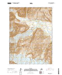
2017 Map of Kenai A-8 SW
USGS Topo · Published 2017About this map
Lake Clark National Park dominates this terrain on the western side of the Cook Inlet region, where high-altitude ice fields feed a complex hydrological system. The movement of ice is recorded through the prominent Johnson Glacier in the north and Double Glacier further south, while Lateral Glacier and Red Glacier define the southwestern reaches of the sheet. These massive ice bodies serve as the primary headwaters for the Johnson River, which flows through the central valley toward the coast. The topography is defined by the steep drainage basins of these glacial systems, including the path of Red Cr in the southeast. This survey provides a precise look at the glacial margins and drainage patterns within the protected wilderness of the Kenai Peninsula Borough during the early twenty-first century.
Find a feature on this map
12 named features on this map. Tap any name to fly to it.
Don’t see what you’re looking for? This feature index may not catch every label — zoom into the map to look around manually.
Map Details
Editions of this 2017 Kenai A-8 SW Map
This is the sole edition of this map. No revisions or reprints were ever made.
Other maps of this area

1944 · Kenai
USGS Topo · 1:250,000

1946 · Lake Clark
USGS Topo · 1:250,000

1950 · Kenai
USGS Topo · 1:250,000

1951 · Lake Clark
USGS Topo · 1:250,000

1951 · Seldovia
USGS Topo · 1:250,000

1952 · Iliamna
USGS Topo · 1:250,000

1957 · Iliamna
USGS Topo · 1:250,000

1958 · Iliamna D-1
USGS Topo · 1:63,360
1958 · Seldovia D-8
USGS Topo · 1:63,360

1958 · Lake Clark A-1
USGS Topo · 1:63,360