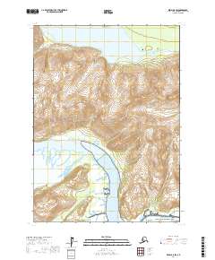
2017 Map of Kenai B-8 SW
USGS Topo · Published 2017About this map
Lake Clark National Park dominates this portion of the Kenai Peninsula, showcasing a landscape defined by dramatic glacial and tidal interactions. The Tuxedni River drains the high alpine country, flowing southeastward into the expansive waters of Tuxedni Bay. To the north, Crescent Lake sits at the head of the Lake Fork Crescent River, illustrating the complex drainage patterns of the Alaskan interior. This 2017 survey details the topographical contours of the area, where tidal flats meet steep mountain slopes near Magnetic Island. The presence of these protected lands and undeveloped waterways highlights a region focused on conservation and natural resource management, where the physical terrain remains largely untouched by permanent settlement.
Find a feature on this map
10 named features on this map. Tap any name to fly to it.
Don’t see what you’re looking for? This feature index may not catch every label — zoom into the map to look around manually.
Map Details
Editions of this 2017 Kenai B-8 SW Map
This is the sole edition of this map. No revisions or reprints were ever made.
Other maps of this area

1944 · Kenai
USGS Topo · 1:250,000

1946 · Lake Clark
USGS Topo · 1:250,000

1950 · Kenai
USGS Topo · 1:250,000

1951 · Lake Clark
USGS Topo · 1:250,000

1958 · Lake Clark A-1
USGS Topo · 1:63,360

1958 · Lake Clark B-1
USGS Topo · 1:63,360
1958 · Kenai A-8
USGS Topo · 1:63,360

1958 · Kenai B-8
USGS Topo · 1:63,360

1958 · Lake Clark
USGS Topo · 1:250,000

1958 · Kenai
USGS Topo · 1:250,000