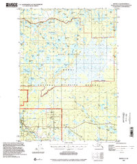
1992 Map of Kenai C-2
USGS Topo · Published 2002About this map
Sterling and the nearby community of Naptowne anchor the southwestern portion of this 1992 update, where the Sterling Highway provides a primary corridor through the Kenai Peninsula. Much of the surrounding landscape is defined by the Kenai National Wildlife Refuge and the Kenai Wilderness, areas characterized by a dense network of water bodies such as Big Merganser Lake, Coyote Lake, and Lake Bratlie. The map reveals the logistical infrastructure of the era, including a Landing Strip, a Pumping Sta, and several Gravel Pits that suggest localized industrial or maintenance activity.
Find a feature on this map
84 named features on this map. Tap any name to fly to it.
Don’t see what you’re looking for? This feature index may not catch every label — zoom into the map to look around manually.
Map Details
Editions of this 1992 Kenai C-2 Map
This is the sole edition of this map. No revisions or reprints were ever made.
Other maps of this area

1944 · Kenai
USGS Topo · 1:250,000

1950 · Kenai
USGS Topo · 1:250,000

1950 · Kenai C-3
USGS Topo · 1:63,360

1950 · Kenai B-1
USGS Topo · 1:63,360

1950 · Kenai B-3
USGS Topo · 1:63,360

1951 · Kenai D-3
USGS Topo · 1:63,360

1951 · Kenai B-2
USGS Topo · 1:63,360

1951 · Kenai C-1
USGS Topo · 1:63,360

1951 · Kenai C-2
USGS Topo · 1:63,360

1951 · Kenai D-1
USGS Topo · 1:63,360