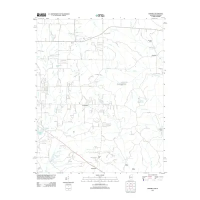
2012 Map of Kendrick
USGS Topo · Published 2012About this map
Farmington and Kendrick anchor the landscape of Alcorn County along the Tennessee border, where the terrain is defined by a dense network of creek drainages. The hydrologic system is intricate, featuring the Sevenmile Creek Drainage Ditch and numerous small lakes like Waukomis Lake and Hillandale Lake. This region shows a transition from agricultural plots to wooded hollows, such as Sorghum Hollow and Lewis Hollow. For family historians, the area is scattered with significant burial sites including Marvin Cem and Wyly Cem. The presence of the Glen Lookout Tower near Strickland suggests a vantage point over the timbered ridges and the headwaters of Coke Cr.
Find a feature on this map
48 named features on this map. Tap any name to fly to it.
Don’t see what you’re looking for? This feature index may not catch every label — zoom into the map to look around manually.
Map Details
Editions of this 2012 Kendrick Map
This is the sole edition of this map. No revisions or reprints were ever made.
Other maps of this area

1935 · Doskie
USGS Topo · 1:24,000

1935 · Leedy
USGS Topo · 1:24,000

1935 · Glens
USGS Topo · 1:24,000

1936 · Counce
USGS Topo · 1:24,000

1936 · Kendrick
USGS Topo · 1:24,000

1936 · Michie
USGS Topo · 1:24,000
1949 · Counce
USGS Topo · 1:24,000

1949 · Michie
USGS Topo · 1:24,000

1950 · Corinth
USGS Topo · 1:62,500

1950 · Kendrick
USGS Topo · 1:24,000