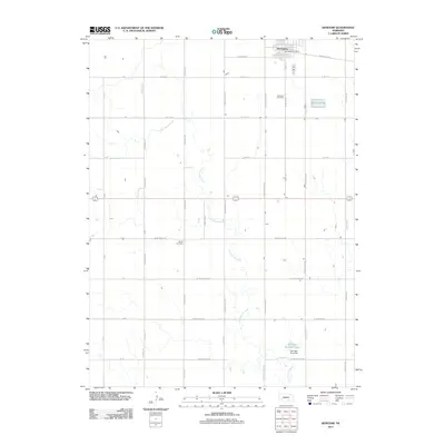
2011 Map of Kenesaw
USGS Topo · Published 2011About this map
Kenesaw serves as the primary hub of this agricultural landscape in Adams County, defined by its traditional grid and essential civic landmarks like the Kenesaw Post Office. The surrounding territory is carved by the meandering path of Cottonwood Creek, which flows southeast across a plain dominated by section-line roads. This rural infrastructure supports long-standing community sites, including Kenesaw Cemetery just south of the main settlement and Shiloh Cemetery further afield near W Idlewilde Rd. Towards the southern edge of the survey, the landscape shifts with the presence of Shurigar Brothers Lake and the Shurigar Bros Dam, indicating localized water management and private landholdings that have shaped the region's development. The map meticulously records the transition from town streets like W Kenesaw Blvd to the extensive network of county roads that facilitate the area's farming economy.
Find a feature on this map
36 named features on this map. Tap any name to fly to it.
Don’t see what you’re looking for? This feature index may not catch every label — zoom into the map to look around manually.
Map Details
Editions of this 2011 Kenesaw Map
This is the sole edition of this map. No revisions or reprints were ever made.
Other maps of this area

1894 · Kenesaw
USGS Topo · 1:62,500

1894 · Minden
USGS Topo · 1:62,500

1896 · Wood River
USGS Topo · 1:125,000

1897 · Red Cloud
USGS Topo · 1:125,000

1955 · Grand Island
USGS Topo · 1:250,000

1957 · Grand Island
USGS Topo · 1:250,000

1958 · Grand Island
USGS Topo · 1:250,000

1962 · Denman
USGS Topo · 1:24,000

1962 · Prosser
USGS Topo · 1:24,000
1962 · Gibbon South
USGS Topo · 1:24,000