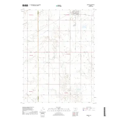
2017 Map of Kenesaw
USGS Topo · Published 2017About this map
Kenesaw serves as the primary hub of this landscape, situated along the northern edge where a network of residential streets like W Pine St and S Railroad St meet the agricultural corridor. The town's proximity to the rail line is evident in its street layout and the presence of Kenesaw Blvd. Outside the residential center, the terrain is defined by a rhythmic grid of rural roads and the winding path of Cottonwood Cr, which cuts through the central sections. For those tracing local history, the map identifies significant burial grounds including Kenesaw Cem just south of town and the more isolated Shiloh Cem to the southwest. To the southeast, Shurigar Brothers Lake provides a notable hydrologic feature in a region otherwise dominated by section-line farming and the boundary between Kearney and Adams counties.
Find a feature on this map
37 named features on this map. Tap any name to fly to it.
Don’t see what you’re looking for? This feature index may not catch every label — zoom into the map to look around manually.
Map Details
Editions of this 2017 Kenesaw Map
This is the sole edition of this map. No revisions or reprints were ever made.
Other maps of this area

1894 · Kenesaw
USGS Topo · 1:62,500

1894 · Minden
USGS Topo · 1:62,500

1896 · Wood River
USGS Topo · 1:125,000

1897 · Red Cloud
USGS Topo · 1:125,000

1955 · Grand Island
USGS Topo · 1:250,000

1957 · Grand Island
USGS Topo · 1:250,000

1958 · Grand Island
USGS Topo · 1:250,000

1962 · Denman
USGS Topo · 1:24,000

1962 · Prosser
USGS Topo · 1:24,000
1962 · Gibbon South
USGS Topo · 1:24,000